¶ Export LAS Bounded by Shape
This function allows users to export a part from the point cloud using a polygon area. A polygon shape shall be used as the active shape to use this function. The area within the polygon - or if multiple polygons can be found in the shape, all - will be exported to a new LAS file regardless of the number of input LAS files (which means tiled input also results in a single output).
If the polygons are set and the function is started, the following settings panel will appear:
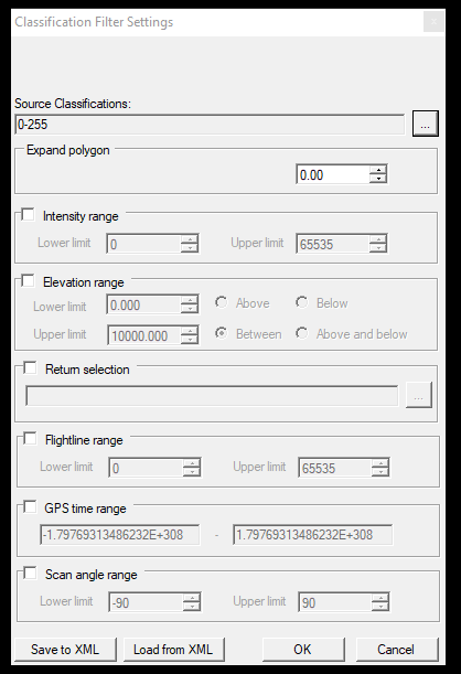
In this panel, multiple options are available to filter the input data.
- Source Classification—Select the classes the user would like to export within the polygon area. If only the ground class is selected, the output file will contain only the ground class for the polygon area(s).
- Expand polygon—The offset value for the polygon can also be positive or negative if the user needs a buffer area of the cloud around it.
- Intensity range - This option is turned off by default. If the user selects the checkbox, a minimum and maximum intensity value can be chosen, which the user would like to include in the export LAS from the input file(s).
- Elevation range—This option is turned off by default. However, if the user selects the checkbox, an elevation range can be selected that the user would like to include in the exported LAS file.
- Return selection—This option is turned off by default. The return number can be selected for the output file if the user selects the checkbox. For example, the user can export only the first returns from the input LAS file(s) to an output LAS file. Please note that this information might not be coded to the input LAS file, or the scanner cannot measure multiple returns.
- GPS time range—This option is turned off by default. If the user selects the checkbox, a GPS time range within which the user would like to have the output file can be selected. Please note that the post-processing software might not code this information into the LAS file.
- Scan angle range—This option is turned off by default. If the user selects the checkbox, the scan angle range for the output can be selected. Please note that the post-processing software might not code the scan angle into the LAS file. This information is commonly missing from the LAS files.
- Save to XML - Save the setting to an XML file so the user can reuse it later on.
- Load from XML - Load a previously saved setting from an XML file.
After the settings are set, press OK. The software will prompt the user to select the output file location and filename. The software will notify you when the export has been finished.