¶ E57-LAS Converter
The E57 converter is currently in development; the presented description and user interface might differ from the final one. Currently, not all types of source data (TLS, MLS, ALS, SLAM) are supported; discuss the current options with our support.
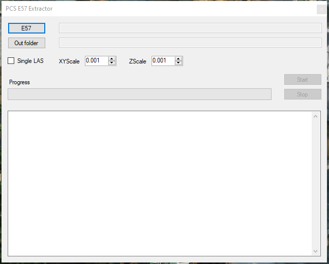
The E57 converter allows the PCS users to convert E57 point cloud files to LAS files (as optimised), and if the file contains the images, those will also be extracted to TopoDOT IPRJ format. The E57 converter is available from the 2024.05.10 version PCS installer and can be accessed from the PCS folder running E57.exe. The user can select an E57 file, and the tool will process it to an output folder. After starting the tool, it might not appear on the tray among the running programs. The user might need to select the window or roll with ALT+TAB to get there and make sure it seems.
The description of the functions are the following:
E57 - Select the E57 file
Out folder - Select the output folder.
Single LAS - As the E57 might store the clouds per scan position (for TLS) or per record (for MLS), the LAS files will be generated accordingly. All clouds will be extracted to a single LAS file if the Single LAS is selected. We firmly recommend not using a single LAS except for a specific reason or if the LAS dataset does not exceed 10 GB. The optimisation of a single LAS file is significantly higher compared to smaller chunks.
XYScale - XY scale factor setting for the LAS file. This function sets the LAS header scale factor. It is not the same as the coordinate scale factor. Leave the default setting.
ZScale - Z scale factor setting for the LAS file. This function sets the LAS header scale factor. It is not the same as the coordinate scale factor. Leave the default setting.
Start - Start the tool. The button is inactive until the E57 file is selected.
Stop - Stop the running process.
The progress bar shows the progress of the conversion. The logging area will display which image or cloud is being extracted.
After the conversion, the LAS files can be opened in PCS along with the TopoDOT IPRJ files. Please note that the image alignment is dependent on the post-processing. PCS cannot adequately visualise the cloud with the images if the camera is not set correctly during the post-processing.