¶ Export Lattice Model
Exporting a lattice model allows the user to extract a regular grid based on the set parameters from the point cloud. This function can create detailed surface models based on discrete points. The user shall keep in mind that the quality of the lattice is highly dependent on the input data. The lattice points are placed in the middle of the designed grid, and the elevation value is taken based on the settings.
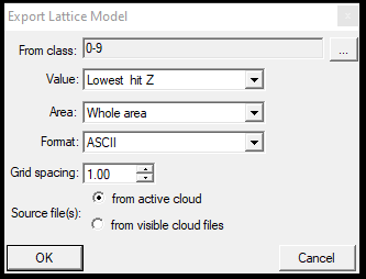
After starting the function, the following settings can be set:
- From class - Set the input classes. Please keep in mind the classification and its quality when picking the classes.
- Value - This option sets the grid point, for example, the lowest or highest hit Z value, which will pick the lowest or highest elevation point from the point cloud for the grid location.
- Area - This option can be used to limit the extraction area. The whole area will extract the grid everywhere, but the polygon SHP area can also be used to limit the extraction area.
- Format - Specify the output format. It is recommended to use the ASCII as this can be used further in PCS.
- Grid Spacing - Specify the grid for the exported lattice model; one point will be placed at the middle of the grid cell, and the lowest Z value from the grid will be used as elevation for this point.
- Source File(s) - Specify if only the active or only the visible clouds shall be targeted with the tool
After pressing OK, the software asks for an output filename and location, where the ASCII (txt) file will be saved. When the software finishes the export, a window will notify the user.
The exported lattice can be used in various software like QGIS, ArcMap, AutoCAD, etc. PCS can further use the created lattice models as the following:
- Create a point cloud from the lattice - In this case, the text file will be turned into an LAS file by PCS, which can also be used. This can be useful for creating a "rough ground" from the software, and from this rough ground, a triangulated file can be made, which can be used as a base for a fine-ground classification. The user can reach this function from the Tools menu - Convert 'text' to LAS option. After selecting the tool, it will ask for the ASCII file and ask the user to provide the scale factor for the conversion. The default conversion scale is 0.001 for XY, which is the proper setting. If it is increased or decreased, it will distort the result, so keeping it at the default value is recommended. After the conversion, the LAS file shall be opened using the Project Manager's Open Cloud option. The generated cloud shall be optimized first.
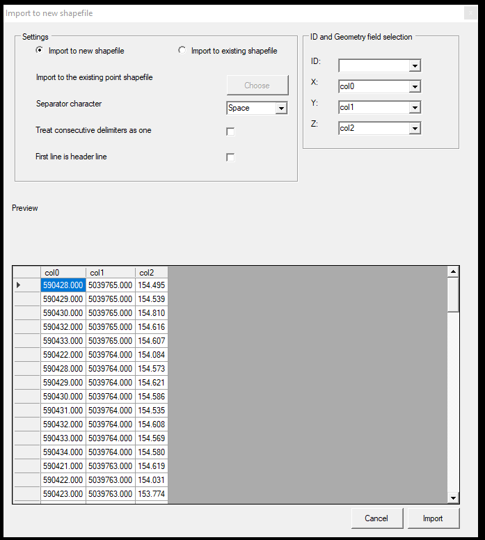
- Create a point SHP from the ASCII file - The software will create a point SHP from the ASCII file. The created file won't have any attribute above the ID field. The user can start the function by right-clicking on Vectors at the Project Manager and selecting Import TXT to PointZ SHP. After the function is started, the software will offer settings for the conversion, such as which column coordinates or if the TXT file has a header. After the conversion, the SHP will be added to the project. Please note that this function can also be used for other types of TXT files with different structures and column orders.