¶ Active objects
In PCS, all data groups (rasters, clouds, vectors, trajectories, geophotos, camera calibrations) can have one - and only one - active “layer”. This active “layer” can be the target for any modification. For example - in standard cases - the user can edit only the active shape file, where the user can perform the extraction or alterations.
The active layer is marked underlined, and the text colour of the elements changes to blue at the Project Explorer. The user can make a layer active by right-clicking on it and selecting Make Current or double left-clicking on the selected layer.
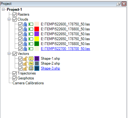
As presented in the example image, each group has an active object. This object can be modified. In some cases, the active layer affects the functionality of the tools. For example, the Create New command creates a point, polyline or polygon according to the active SHP, or the user cannot run a contour generation if the active object is not the triangulated layer. Some icon displays may vary according to the active layer. The user can modify the attribute table of the active and non-active layers.
Some tools may be able to create or modify multiple layers, not just the active layer. In this case, the function name will indicate this. Some functions can be run only if a specific type of layer is active.
If the user modifies multiple layers, it is highly recommended that all vectors or LAS files be saved by selecting them and pressing Save from the right-click menu.